| Carbon |
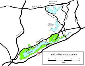
| DESCRIPTION: These two watershed reservoirs hold over 10 billion gallons of water and are administered by the Bethlehem Water Authority. More than 22 square miles of land are open to the public. (The lakes themselves — Wild Creek with 304 acres of water and Penn Forest with 480 acres — are not public.) This area is remote and there are no human residents behind the Wild Creek Dam breast to the feeder streams of Penn Forest. Trails are abundant. Overlooks at both sites are opened by water company personnel daily from 8:00 AM to 3:00 PM. These locations can easily be visited in conjunction with a visit to Beltzville State Park. See the separate site description for the park. The trails are not marked. It is best to obtain the 7.5 minute Pohopoco USGA quadrangle before doing extensive walking. The area is patrolled by Bethlehem Water Supply personnel in green trucks with the city seal on the door. They are very cooperative and helpful. There are sensitive nesting species in the area, especially raptors, so exercise good judgment if you come across one during the breeding season. Restrooms are available at the Wild Creek overlook and the Penn Forest overlook. There are rattlesnakes in the Hell Hollow Road area. Description adapted from Birds of the Lehigh Valley and Vicinty, available at http://www.lehigh.edu/~bcm0/lvas/BOLV.htm. |
DIRECTIONS: The entrance to Wild Creek Reservoir is the starting point of the tour. To reach the entrance, first follow directions in the site description for Beltzville SP. From the main park entrance at Beltzville SP, head east on Pohopoco Drive 4.1 miles Turn left at the sign into the entrance for Wild Creek Reservoir. Follow the entrance road into Wild Creek Reservoir. At the end of the road you can see the reservoir. Bald Eagle have been spotted here many summers and during migration and in the winter. Diving ducks are regular in winter and migration. In summer, Pine and Prairie warblers nest in this vicinity along with Hermit Thrush and Veery. These, along with other common nesting birds, can be found by walking the trails around the lakes. Returning to Pohopoco Drive, continue 0.4 mile east to its intersection with Penn Forest Drive. Turn left onto Penn Forest Drive. Follow this road about 2.0 miles to the Rear Cove area. The Rear Cove, viewed from the road, is one of the better places to see waterfowl. Entrance to many of the roads in this area is barred with bright orange gates to keep the roads closed to vehicular traffic. Park to the side of any of these gates and walk in along the road. Plantings of pine and spruce are on both sides of the roads. Winter finches including crossbills, Evening Grosbeak, and Common Redpoll can sometimes be found in the fall and winter. Pileated Woodpecker and Golden-crowned Kinglet are year-round residents. Spring can give good views of Bay-breasted, Cape May, Magnolia, and other warblers in the spruce groves. Common Loon can be heard in spring as they rest on the water during migration. Common Merganser nest here and Great Blue Heron can be seen throughout the year. Continuing north on Penn Forest Drive, Gate 2 at Penn Forest is 1.3 miles from the Rear Cove area. This area overlooks the reservoir. At night in the summer Barred and Great Horned owls, Eastern Screech-Owl, and Whip-poor-will may be heard. Be careful driving as Whip-poor-will sit along the road. Coyotes have also been heard howling, and deer, Wild Turkey, and Ruffed Grouse cross the road. One of the more remote roads in the area can be reached by continuing on Penn Forest Drive northwest from the Penn Forest Overlook. Go 1.4 miles and turn right onto Hell Hollow Road (there is no sign here but two entrances). This road goes along the back of the reservoirs, crossing a few feeder streams. Walking along the road and these streams can be very productive in migration, although walking is difficult if you are not on a trail. Cooper's Hawk, Broad-winged Hawk, Hermit Thrush, Canada Warbler, Worm-eating Warbler, and American Redstart can be found along this road in summer. |
|
Maps - other than Google (Click on map for larger view)
|
|
Sub-sites |
Photos 
|
| Posted: 2009-10-24 00:00:00 Updated: |